

Version PIX4Dcapture Pro -Optimal 2D Mapping and 3D Modeling
Unlock the power of your drone with PIX4Dcapture Pro for optimal 2D mapping and 3D modeling. Precision flight made easy: the ultimate RTK drone companion app. Terrain awareness: Push the limits of aerial mapping by getting accurate maps when flying over uneven terrain. This function helps pilots prevent gaps in dataset collection by adapting to the terrain being surveyed. Network RTK: Get reliable and accurate maps and models thanks to careful flight planning. PIX4Dcapture Pro enables Network RTK support to achieve centimeter level drone positioning and accuracy for results that are true-to-reality. Offline maps: Plan your missions in advance so you can work offline using a downloaded street or satellite basemap. Get a visual reference before you go out into the field to streamline your workflows.
From planning to processing:
the comprehensive solution for capturing accurate data
1. Select your drone
Select your drone from the wide range of supported models, including major brands such as Parrot and DJI.
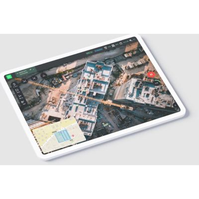
2. Create a Data acquisition plan with one or several missions
Use a flight plan that suits your data acquisition project - be it a structure or large area.
3. Adjust your drone flight plan and parameters
When you arrive on-site, prepare your flight according to the conditions you find.
4. Start and fly
You're ready for the sky! Take off and fly your flight plan right away.
5. Upload for processing to PIX4Dcloud
Let the software do the work. Get results you can measure, analyze, and share with ease.